Have I mentioned that I’m climbing Mt. Fuji in August?! Well, I am. Everything has been arranged as far as accommodations and travel, so now I’m amassing a wish list on REI to keep track of the gear I need to buy. In lieu of this fact I also decided to go hiking as much as possible until August 6th. I’m much more confident in my train and road navigation abilities. The recent discovery of my bicycle having an internal gear system made it much more amiable to ride up and down the hilly valley roads to get to a trailhead. Learning Japanese hiking vocabulary is a step-by-step journey but I’m making progress in that area as well and was able to find a very helpful site for hopeful hikers. The absence of a car makes it a little tricky and I have to be more picky about the mountains I climb, but it always promises adventure for me and the party involved.
Recently Eric was the hiking buddy victim and he accompanied me on a hike up Mt. Ootakine. Although I woke 2 hours before I had to leave the house, an impromptu conversation had me scrambling to pack my things at the last minute because I couldn’t say goodbye. I whipped up some pancake mix and threw in blueberries, filled my water bladder for the first time and hoped it wouldn’t leak on it’s inaugural run. Eric was ready to go and came to check on me…good thing because I had since forgotten about the pancakes cooking and ended up charring a few. Oops. Steaming hot they packed in tinfoil, I stuck some veggies in a plastic container, grabbed the camera and battery from the charger, bug repellant and sunblock from the dresser, sunglasses from atop the mirror and off we went!
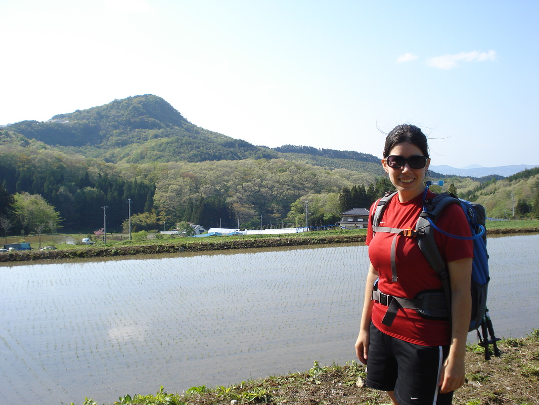
We took a train 3 stops to the South East, a direction I’ve never taken on the train line. It was there I remembered that the map I’d painstakingly written out the night before was still lying on my bedroom floor by the computer. Oops. Riding further into the countryside we stepped lightly onto a single empty platform, the nine o’clock sunshine promising a slightly view from the mountain summit. At such a small station there is no one to man it so we stuck our tickets into a wooden box by the entrance. Walking along the road we passed local farmers carefully planting each baby rice plant by hand in the flooded fields. Our road weaved up the mountainside for an hour. We passed some local tourist attractions like a cave entrance and a “pure water” bottling plant. At the top of the ridge we walked through a nifty looking campground that had large and small cabins available to rent.
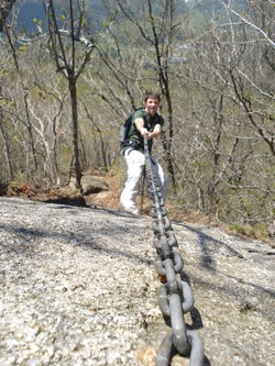
Walking over the summit of “Sendaihiwara” our road finally began to slope down. At a fork in the road I suddenly wished I had remembered the map. We went right….after a few minutes we turned around and took the left fork. The correct one. Soon we came to the trailhead. The trailhead didn’t let us down and led straight up the southwest ridge of the mountain. Some parts were actually pretty steep! I changed from my road running shoes to my hiking shoes and began the ascent. It involved some awesome trees and short bamboo brush, a few rocks to climb over and some ladders and chains to climb up the dangerous places. We passed only 3 people who were coming down the mountain.
Recently Eric was the hiking buddy victim and he accompanied me on a hike up Mt. Ootakine. Although I woke 2 hours before I had to leave the house, an impromptu conversation had me scrambling to pack my things at the last minute because I couldn’t say goodbye. I whipped up some pancake mix and threw in blueberries, filled my water bladder for the first time and hoped it wouldn’t leak on it’s inaugural run. Eric was ready to go and came to check on me…good thing because I had since forgotten about the pancakes cooking and ended up charring a few. Oops. Steaming hot they packed in tinfoil, I stuck some veggies in a plastic container, grabbed the camera and battery from the charger, bug repellant and sunblock from the dresser, sunglasses from atop the mirror and off we went!
We took a train 3 stops to the South East, a direction I’ve never taken on the train line. It was there I remembered that the map I’d painstakingly written out the night before was still lying on my bedroom floor by the computer. Oops. Riding further into the countryside we stepped lightly onto a single empty platform, the nine o’clock sunshine promising a slightly view from the mountain summit. At such a small station there is no one to man it so we stuck our tickets into a wooden box by the entrance. Walking along the road we passed local farmers carefully planting each baby rice plant by hand in the flooded fields. Our road weaved up the mountainside for an hour. We passed some local tourist attractions like a cave entrance and a “pure water” bottling plant. At the top of the ridge we walked through a nifty looking campground that had large and small cabins available to rent.
Walking over the summit of “Sendaihiwara” our road finally began to slope down. At a fork in the road I suddenly wished I had remembered the map. We went right….after a few minutes we turned around and took the left fork. The correct one. Soon we came to the trailhead. The trailhead didn’t let us down and led straight up the southwest ridge of the mountain. Some parts were actually pretty steep! I changed from my road running shoes to my hiking shoes and began the ascent. It involved some awesome trees and short bamboo brush, a few rocks to climb over and some ladders and chains to climb up the dangerous places. We passed only 3 people who were coming down the mountain.
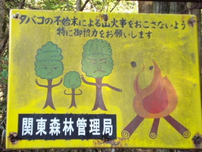
Awesome fire prevention sign at the trailhead. It says, "You made Baby Tree cry! Shame on you!"
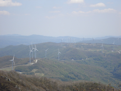
The top was somewhat anticlimactic as it was the post for a communications base for the Japanese military. 1,192 meters (3910 ft.) if you’re interested. We walked around the chain and barbed wire fence that hogged the summit before settling on a lovely view of the lazy wind turbines chilling out on the south ridge. Do you know how huge those things are?! I passed one on the freeway once…one blade was being carried by the entire length of a flatbed semi truck. As we ate our lunch in the sunshine we theorized the probability of surviving a flight through the gap in the blades while hang-gliding. According to our non-calculations, one has 5% chance of survival, all dependent on wind speed and the length of your glider. (In case you were curious). We tried to look at the ocean through the binoculars but it was too hazy to see it clearly. I did see two large towers by the coastline and couldn’t help but wonder if they were from the reactor plants.
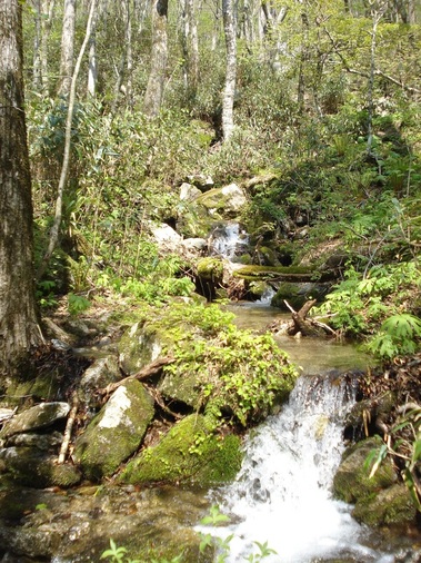
On the way back we hunted for and found the overgrown west trail. Quite steep and slippery, it more than made up for its faults when it followed a stream for the last mile or so of the trail. The route crisscrossed countless times back and forth, allowing us to jump, leap, and otherwise tip-toe across river rocks to make it to the opposite bank. This miniature lush mountain paradise was further enhanced by the joyful songbirds and croaking frogs encouraging us along the way.
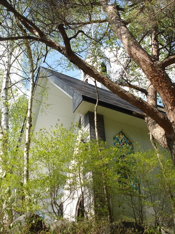
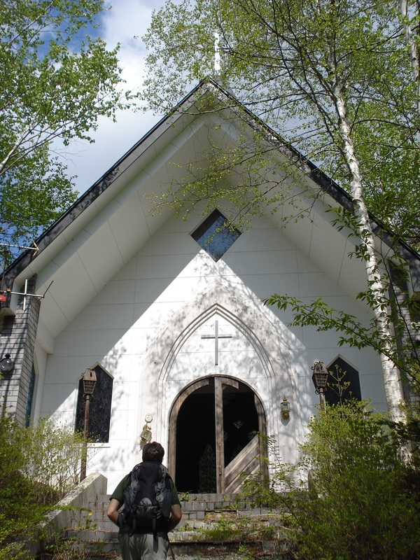
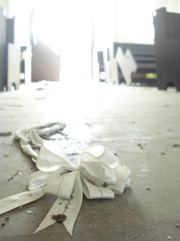
Coming out of the woods we happened upon a cute little church building complete with a rock wall and white birch tree border. Approaching the front of the building there was obvious earthquake damage to the tile staircase and the rock retaining wall. One of the front doors was completely gone and most of the windows had left their glass on the floor. Fans were hanging by wires from the ceiling. A piano left out collecting dust was luckier than the pulpit covered in rat droppings. Discarded programs from a wedding were strewn about the floor as were relinquished ribbon pew decorations. Silently we walked through the deserted set, imagining a wedding being interrupted by a violent earth shaking, windows shattering and people screaming as they run outside only to be met by crumbling rock walls and cracked tiles. Of course we can’t say for certain that is what occurred, but the remnant pieces certainly fueled the imagination.
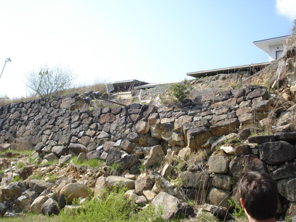
After leaving the chapel we walked a few paces down the road only to discover that it was owned and operated by the hotel perched above the tranquil rice paddies. The hotel had long since been abandoned as well, though a bit more methodically than the chapel. All the furniture, documents, props, and other easily movable/sellable items had been removed, right down to the light fixtures in the ceiling where bare wires now crept out of dark holes. They took everything but the kitchen sink and the industrial laundry machines…and the disco ball. What a shame to leave THAT behind! The windows were mostly shattered of course, and the parking lot was completely impaired since half of it had slid down the hill into the road. A lone boulder sat in the middle of the pavement, content in its new location.
We chose a different road to return by, this also requiring boarding at a station further down the line. We began descending the mountain speedily enough but realized that we had quite a ways to go. In an effort to not miss Bible Study that evening we decided to try our thumbs at hitch-hiking. Two cars later (and those were the ONLY two cars coming down the mountain) an old lady pulled over and offered us a ride into town. We had a lovely little chat with her for the next five minutes or so as we enjoyed the sensation of sitting and moving. After nothing but walking only up or downhill for hours it was a very welcome feeling. It turned out that our kind driver was headed to the store directly across from the station! Everybody benefitted from this encounter, especially since we had four minutes to spare before the next train pulled in! Had we walked into town we would have had to wait another hour and a half for the train and arrive home late for the meeting. Awesome. And a definite win for my first ever hitch-hiking experience. Sitting on the train home I opened my pack to partake of the last burned pancake. It was delicious.
Hopefully my next summit will be Mt. Bandai, the local volcano to the west sitting at 1816 meters (5,958 ft.)
 RSS Feed